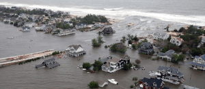
Coastal communities are particularly vulnerable to storms, flooding, and extreme weather, and it is important to consider resilience when planning and building in these regions. Photo ©Jie Gong.
CAIT researcher Dr. Jie Gong’s recent work has focused on promoting coastal urban community resilience, including leading remote sensing-based post-disaster reconnaissance missions during Hurricane Sandy, Hurricane Harvey, and Hurricane Michael with the goal of advancing damage assessment methods and turning data into actionable resilience knowledge. Now, he will continue using innovative technology and methods to promote community resilience in this area through a new project with FEMA/NJOEM.
Rutgers Center for Advanced Infrastructure and Transportation (CAIT) was recently awarded a 2-year, $1.1 million Federal Emergency Management Agency (FEMA) grant to characterize the conditions of buildings and infrastructure along New Jersey’s 500-Year Flood Plain relevant to future storm threats using remote sensing, cloud computing, and AI-based technologies.
The project, “Terrestrial LiDAR Mapping and Analysis of Buildings and Infrastructures within the New Jersey 500-Year Flood Plain,” was awarded as a Hazard Mitigation Grant Program (HMGP) Planning grant to Rutgers through the NJ Office of Emergency Management.
Dr. Jie Gong, a CAIT-affiliated researcher and project leader, said that this project is designed to generate data and products that support efforts in flood risk mitigation in the face of future hurricanes, flooding, and sea level rise.
“We have unique geomatics engineering and visualization capabilities here at Rutgers,” Dr. Gong said. “In this project we will be putting those capabilities to use by collecting high-resolution geospatial data and developing digital elevation models that can help decision makers in coastal cities and regions understand what areas/assets are most vulnerable to future storm events and make more informed mitigation decisions.”
Specifically, the Rutgers CAIT team will collect mobile terrestrial LiDAR and georeferenced street-level digital images along all roadways in the 500-year flood plain in New Jersey. Based on the collected data, the team will then develop digital elevation models for individual residential properties and determine the degree to which first floor elevations of rebuilt residences are following FEMA’s Preliminary Flood Insurance Rate Maps (FIRMs).
This information can then be used by decision makers to better understand their infrastructure and what might be vulnerable to storms, as well as support future initiatives in flood risk mitigation.
Dr. Gong said that coastal cities in particular are vulnerable to storms, flooding, and other extreme weather events due to their inherent population density, complex infrastructure, and shifting environments. Much of his recent work has focused on this area, including using geospatial big data and developing data analytics to support city management applications, remote sensing, data modeling, and more.
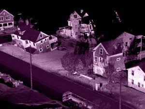
Lidar scan of houses damaged from Hurricane Sandy.
Notably, he lead remote sensing-based post-disaster reconnaissance missions following Hurricane Sandy and other storms, where a team of researchers deployed LiDAR technology to gather data and images that helped create 3D elevation models of infrastructure impacted by the storm along the New Jersey coastline for the purpose of improving future infrastructure resilience and building.
This new project is focused on coastal resilience and asset management as well. Dr. Gong said that it will help provide accurate building data and better identify assets that are vulnerable to major storm events.
“Research to make these coastal cities more resilient to storms and natural disasters is critical for asset owners moving forward,” he said. “We plan to provide FEMA and our partners with actionable data and products through this grant that can support an array of future infrastructure initiatives.”