Working with the University of the Virgin Islands, Rutgers CAIT researchers have developed a Flood Risk and Resilience Analysis Tool that can be used to quantitatively assess and visualize risk for roadways and other infrastructure susceptible to flooding and storms. The tool was built based on real flood data and the existing transportation system in the US Virgin Islands.
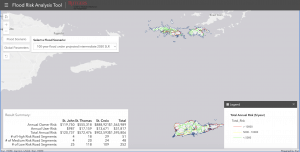
CAIT’s Flood Risk Analysis Web Dashboard.
CAIT researchers analyzed how infrastructure and the transportation system in the U.S. Virgin Islands could be impacted by sea level rise alongside a 100-year storm scenario, and developed an innovative tool to inform community resilience planning based on the findings.
The tool is a GIS-based web platform with an input-output dashboard that can be used to quantitatively assess and visualize risk for roadways and other infrastructure susceptible to flooding and storms. It is built around a risk-integrated analytical framework constructed in partnership with the University of Virgin Islands (UVI) and the US Virgin Islands Department of Public Works—and incorporates real data from the US Virgin Islands and multiple future flood scenarios considering sea level rise.
Depending on user input, the platform can apply vulnerability ratings of specific assets such as roads and pavement to flooding and other hazards. It then presents life-cycle costs for each, said Dr. Dan Barone, a jointly appointed Associate Research Professor within the Rutgers University Department of Marine and Coastal Sciences, Center for Advanced Infrastructure and Transportation, and Department of Geography.
It accomplishes this by incorporating a resilience-based life-cycle cost analysis system that advances the Risk Analysis and Management for Critical Asset Protection (RAMCAP) process, which was first developed after the September 11, 2001, attacks to assess an assets vulnerability to specific hazards.
The Flood Risk and Resilience Tool’s key features include:
- Flood risks and costs for all segments in the roadway network that can be estimated with and without considering future sea level rise scenarios.
- Total risk levels that are visualized on the map.
- Detailed input data and output risk values shown on the road info page by clicking on/selecting the specific segment; among other features.
“With this information at their fingertips, officials and decision makers can make data-informed asset management decisions that better account for potential risks, support infrastructure durability, and enhance the transportation network,” Dr. Barone said.
While developed for the US Virgin Islands, he added that this tool can also be customized for different assets and is scalable. It can be used by other transportation agencies to better anticipate their own hazards and to maximize the durability of capital-intensive infrastructure.
The comprehensive analytical framework developed also considers both normal and extreme management conditions for different risk-based infrastructure asset management approaches.
This research was supported by the University Transportation Center project, “Risk and Resilience Analysis Tool for Infrastructure Asset Management” at the Rutgers Center for Advanced Infrastructure and Transportation (CAIT).
“The framework and tool producing quantitative cost and risk measures is useful for addressing the high-level questions that agencies face in long-term planning and management decision making, such as project prioritization, resilience planning, and capital planning,” Dr. Barone said. “These resources have the potential to improve infrastructure durability and resilience, save agencies time, and save money over the long-term as well.”