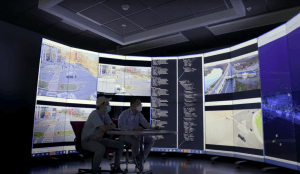
CAIT’s visualization lab lets researchers analyze mobility data collected from roadside sensors.
Led by Columbia University, this grant will develop a new Center for Smart Streetscapes in collaboration with state-of-the-art labs at Florida Atlantic University, University of Central Florida, Lehman College, and Rutgers University/CAIT. Among the facilities, CAIT’s DataCity Smart Mobility Testing Ground will conduct mobility data collection to enable new services and novel technology developments that will improve safety, efficiency and quality of life for citizens.
More than 80% of Americans and over half the world’s population live in urban areas. High-density cities and their complex infrastructure shape how people live, work and travel. Harnessing this critical information allows for novel technology developments that can provide new mobility solutions, forge more inclusive communities, and improve transportation safety.
The National Science Foundation (NSF) recently announced that it awarded a $26 million, five-year grant to a team led by Columbia University, in partnership with Rutgers University, Florida Atlantic University, University of Central Florida, and Lehman College. The grant will establish a new Gen-4 NSF Engineering Research Center for Smart Streetscapes (CS3) utilizing emerging systems technology.
CS3 will advance livable, safe, and inclusive communities through real-time, hyper-local streetscape applications built on advancements in edge-cloud technology, wireless-optical engineering, visual analytics, computer security, and social science.
“With this grant, we have an opportunity to transform this nation’s streetscapes with smart technologies that address critical safety, equity, privacy, and security concerns,” said Columbia President Lee C. Bollinger.
The research team will be working closely with a diverse cohort of more than 80 non-academic community stakeholders—industry partners, community organizations, municipalities, and K-12 schools. CS3 researchers and partners will collaboratively shape research objectives and application outcomes and support workforce development, internships, industry collaborations, entrepreneurship, student opportunities from middle school through postdoctoral programs, visiting faculty, and community engagement.
“Our partnership provides an unprecedented opportunity to pool the strengths of our institutions, embedded in cities that can serve as models for other urban areas around the world,” said Columbia Provost Mary C. Boyce. “By improving life at hyperlocal scales, we will unlock transformative innovation for communities where it matters most.”
CS3 will explore five application themes: road safety and traffic efficiency, public safety, assistive technologies for people with disabilities, the future of outdoor work, and hyper-local sensing and modeling.
Applications and projects developed will be piloted within three distinct urban testbeds—in New York City (NY), West Palm Beach (FL), and New Brunswick (NJ)—leveraging labs and testbeds located at each institution.
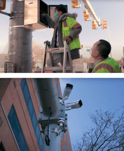
Roadside lidar sensors, edge computing devices, and other technologies have been installed throughout the DataCity test corridor to study traffic and mobility in the region.
In New Brunswick, CAIT’s DataCity Smart Mobility Testing Ground will assist in smart mobility data collection. In partnership with Middlesex County, the New Jersey Department of Transportation, The City of New Brunswick, The New Jersey Economic Development Authority, and industry collaborators such as Iteris and Verizon, DataCity is a 2.4-mile multi-modal corridor between Route 27 to Route 18 in downtown New Brunswick equipped with self-driving-grade high-resolution roadside sensors, edge computing devices, and the latest 5G and Cellular-Vehicle-to-Everything technologies.
This innovative sensor network enables access to smart-mobility services to all travelers on the corridor. The testbed creates new ways to study urban mobility that can improve traffic management, safety, and economic development opportunities.
For example, LiDAR sensors at corridor intersections will give planners real-time traffic analytics to ease congestion and avoid accidents. Digital twins and 3D maps will track traffic flow in real time, and dynamic data will show officials how pedestrians and vehicles interact at critical points on the transportation network, among other developments.
“Acquiring and analyzing mobility data is crucial to developing autonomous vehicles and other smart city technology that can help create a safer pedestrian, cycling, and driving environment,” said CAIT researcher and associate professor Dr. Peter Jin. “DataCity provides a living testbed for implementing these innovative technologies in our community. We are proud to work closely with our partners on this NSF project and leverage resources at our lab to support the Smart Streetscapes initiative.”
On the NSF project, Dr. Jorge Ortiz, an assistant professor in the School of Engineering’s Department of Electrical and Computer Engineering (ECE), will serve as the institutional lead for Rutgers.
His team includes ECE distinguished professor and WINLAB director Dr. Dipankar Raychaudhuri; WINLAB chief technologist Mr. Ivan Seskar; Dr. Peter Jin; and Dr. Mubbasir Kapadia, an associate professor of computer science in Rutgers School of Arts and Sciences.
Rutgers faculty will apply their expertise to develop innovative communication technologies, architectures beyond 5G, and machine learning/AI algorithms that use multimodal data streams from intersections, vehicles, and people.
“This grant allows us to develop a comprehensive research program centered around future human-streetscape interaction—interaction with intelligent agents on a large scale,” Ortiz said. “It will also allow us to explore the common system-related elements necessary to enable a general platform that opens the streetscape to future developers and a wider innovation pipeline. Moreover, it will bring issues of equity and ethics to the fore in the development of these technologies.”